import mikeio
ds = mikeio.read("../data/gebco_sound.dfs2")
ds
<mikeio.Dataset>
dims: (time:1, y:264, x:216)
time: 2020-05-15 11:04:52 (time-invariant)
geometry: Grid2D (ny=264, nx=216)
items:
0: Elevation <Total Water Depth> (meter)A dfs2 file is also called a grid series file. Values in a dfs2 file are ‘element based’, i.e. values are defined in the centre of each grid cell.
import mikeio
ds = mikeio.read("../data/gebco_sound.dfs2")
ds<mikeio.Dataset>
dims: (time:1, y:264, x:216)
time: 2020-05-15 11:04:52 (time-invariant)
geometry: Grid2D (ny=264, nx=216)
items:
0: Elevation <Total Water Depth> (meter)The most convenient way to subset in space is to use the sel method, which returns a new (smaller) dataset, which can be further processed or written to disk using the to_dfs method.
ds.geometry<mikeio.Grid2D>
x: [12.2, 12.21, ..., 13.1] (nx=216, dx=0.004167)
y: [55.2, 55.21, ..., 56.3] (ny=264, dy=0.004167)
projection: LONG/LATds_aoi = ds.sel(x=slice(12.5, 13.0), y=slice(55.5, 56.0))
ds_aoi.geometry<mikeio.Grid2D>
x: [12.5, 12.5, ..., 12.99] (nx=120, dx=0.004167)
y: [55.5, 55.5, ..., 55.99] (ny=120, dy=0.004167)
projection: LONG/LATIn order to specify an open-ended subset (i.e. where the end of the subset is the end of the domain), use None as the end of the slice.
ds.sel(x=slice(None, 13.0))<mikeio.Dataset>
dims: (time:1, y:264, x:191)
time: 2020-05-15 11:04:52 (time-invariant)
geometry: Grid2D (ny=264, nx=191)
items:
0: Elevation <Total Water Depth> (meter)The spatial information is available in the geometry attribute (accessible from Dfs2, Dataset, and DataArray), which in the case of a dfs2 file is a Grid2D geometry.
ds.geometry<mikeio.Grid2D>
x: [12.2, 12.21, ..., 13.1] (nx=216, dx=0.004167)
y: [55.2, 55.21, ..., 56.3] (ny=264, dy=0.004167)
projection: LONG/LATGrid2D’s primary properties and methods are:
xnxdxynydyoriginprojectionxybboxcontains()find_index()isel()to_mesh()See API specification for details.
Use interp() to extract values at a specific coordinate:
da = ds["Elevation"]
da_point = da.interp(x=12.74792, y=55.865)
da_point.valuesarray([-42.69764539])To create a dfs2 file from scratch:
Grid2D geometryDataArrayData arrays must have shape (n_timesteps, ny, nx) for time-varying data or (ny, nx) for static data. The y-axis must increase south-to-north and the x-axis west-to-east, matching the CF conventions.
For complete examples of converting external data to dfs2, see Dfs2-Bathymetry (NetCDF → static dfs2) and Dfs2-GFS (NetCDF → multi-item time-varying dfs2).
import numpy as np
import pandas as pd

grid = mikeio.Grid2D(
    x0=12.0, dx=1.0, nx=3,
    y0=55.0, dy=1.0, ny=4,
    projection="LONG/LAT",
)
grid
<mikeio.Grid2D>
x: [12, 13, 14] (nx=3, dx=1)
y: [55, 56, ..., 58] (ny=4, dy=1)
projection: LONG/LATdata = np.arange(24, dtype=float).reshape(2, 4, 3) # (time, y, x)
data.shape(2, 4, 3)da = mikeio.DataArray(
data=data,
geometry=grid,
time=pd.date_range("2020", periods=2, freq="D"),
item=mikeio.ItemInfo("Elevation", mikeio.EUMType.Elevation),
)
da<mikeio.DataArray>
name: Elevation
dims: (time:2, y:4, x:3)
time: 2020-01-01 00:00:00 - 2020-01-02 00:00:00 (2 records)
geometry: Grid2D (ny=4, nx=3)da.to_dfs("example_geo.dfs2")pgrid = mikeio.Grid2D(
x0=337100.0, dx=10000.0, nx=3,
y0=6122900.0, dy=10000.0, ny=4,
projection="UTM-32",
)
pda = mikeio.DataArray(
data=data,
geometry=pgrid,
time=pd.date_range("2020", periods=2, freq="D"),
item=mikeio.ItemInfo("Elevation", mikeio.EUMType.Elevation),
)
pda.plot();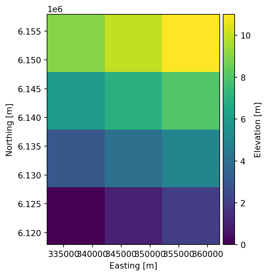
Cleanup:
import os
os.remove("example_geo.dfs2")